Since some years you can download this Smartphone App which can lead you to the Thematic Trails of our Dolomites The main function of this App is the Audio Guide, that tell you about three main themes: • WHERE YOU ARE AND WHERE YOU CAN GO • HISTORY AND SIGNS OF MANKIND • GEOLOGY AND LANDSCAPE

The Dolomites, UNESCO World Heritage, are mainly located in the Veneto Region which wants to spread the beauty, the history and the nature of these precious mountains.

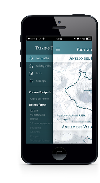
How to study of the itinerary, how to care and prepare the personal equipment are the preliminary stages of each excursion. Thanks to the project "MontagnAmica & Sicura" you can face safely the footpath.

In each Talking Trail you will encounter different points of interest thanks to GPS coordinates. With cultural, historical and landscape information the App will integrate what you already see around you in an astonishing way.

In addition to learning how to listen to the noisy silence of nature, you can use the audio guide to appreciate everything around you with so many cultural and historical information.

In high mountain, hospitality is an opportunity thanks to the many Domolites Hut that you will find in the App, supplied with contact details, technical and logistic information and reception.

In synergy with the CAI's project MontagnAmica & Sicura, you will find here messages, rules, instructions and tips for your safety.
Download Tallking trails' folding